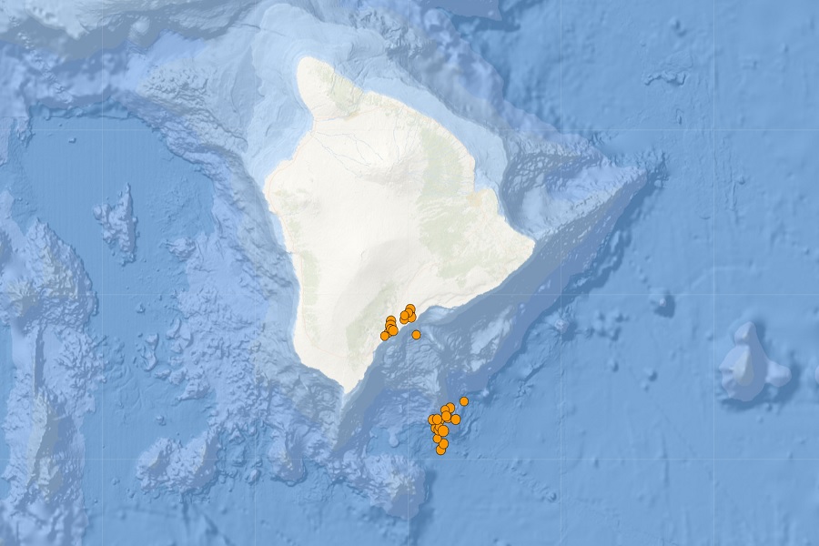
An earthquake swarm on a volcano around the Big Island of Hawaii has prompted the USGS and the Hawaiian Volcano Observatory (HVO) to issue an alert about new activity on Kama’ehuakanaloa. It’s been a busy 36 hours in Hawaii: Tropical Storm Darby passed nearby on Saturday, while an unrelated epic swell brought waves of historic height to the state’s south-facing shores. Now a new seismic swarm has begun on Hawaii’s newest volcano, which scientists believe could be a sign of magma moving. In the past 24 hours, 32 earthquakes have struck the Big Island and adjacent waters, with 18 measuring over the area also known as the Lōʻihi Seamount.
According to an alert issued by HVO, increased seismic activity began beneath the Kamaʻehuakanaloa (Lōʻihi) seamount south of the island of Hawaii on Saturday, July 16, 2022 at approximately 2:00 a.m. local time. The US Geological Survey’s Hawaiian Volcano Observatory detected seismic tremors marked by pulses of seismic energy every 15-20 seconds that were still ongoing at the time of their latest news release. About 24 hours after this activity began, two dozen magnitude 1.8-3.0 earthquakes occurred between 1:30 a.m. and 6:00 a.m. on July 17.

“This seismic activity is likely the result of magma movement beneath the Kamaʻehuakanaloa seamount and currently shows no signs of an eruption occurring,” said Ken Hon, lead scientist at HVO. “If the swarm intensifies or changes significantly, HVO will issue an additional notification. Because of the volcano’s great depth in the ocean and the nature of Hawaiian eruptions, an eruption from Kamaʻehuakanaloa would not pose a threat to the island of Hawaii. Neither the Mauna Loa nor Kīlauea volcanoes show a change in activity associated with this earthquake swarm.” These include the tsunami threat, which scientists say is unlikely with seismic activity at this seamount.
The entire state of Hawaii is made up of volcanoes; The Hawaiian Emperor seamount chain is a well-known example of a large seamount and island chain formed by hot spot volcanism. Each island or submerged seamount in the chain becomes successively older toward the northwest. In the vicinity of Hawaii, the island-to-island age history can be used to calculate the northwestward movement of the Pacific Ocean plate. According to NOAA, the Earth’s outer crust is made up of a series of tectonic plates moving across the planet’s surface. Volcanoes sometimes form in areas where the plates meet. Volcanoes can also form in the middle of a plate, where magma rises until it erupts on the sea floor, at what is called a “hot spot”. The Hawaiian Islands were formed by such a hot spot in the middle of the Pacific Plate. While the hotspot itself is fixed, the plate moves. As the plate moved across the hot spot, the chain of islands that make up the Hawaiian island chain formed.
The Hawaiian Islands form an archipelago that covers a vast area of the North Pacific. The archipelago consists of 132 islands, atolls, reefs, shallow shores, shoals and seamounts stretching 1,500 miles from the island of Hawaii in the southeast to Kure Atoll in the northwest. Kamaʻehuakanaloa is the youngest volcano in the chain and remains an underwater volcano; Its summit is about 3,200 feet below sea level about 50 miles southwest of Mauna Loa volcano, which is the largest in the world. Kamaʻehuakanaloa began forming about 400,000 years ago and is expected to emerge above sea level in about 10,000 to 100,000 years. At its summit, Kamaʻehuakanaloa rises more than 10,000 feet above the sea floor, making it taller than Mount St. Helens before its deadly eruption in 1980.

The fresh activity of Kamaʻehuakanaloa is a reminder that volcanic activity is very lively in Hawaii. While it’s submerged for now, three major active volcanoes grace the Big Island of Hawaii: Mauna Loa, the largest, Hualalai, the quietest, and Kilauea, the most active of the group. Hawaii is also home to Mauna Kea, a dormant volcano that last erupted thousands of years ago. Mauna Kea is the tallest of Hawaii’s volcanoes, and its higher elevations are often covered with a blanket of snow.
Last year, scientists at the Hawaiian Volcano Observatory (HVO) warned with USGS, “While an eruption of Mauna Loa is not imminent, now is the time to reconsider personal eruption plans. Similar to preparing for hurricane season, in an emergency it helps to have an outbreak plan in advance.”
Considered the largest active volcano on earth, Mauna Loa rises to 13,681 feet above sea level. Mauna Loa rises from the Central Pacific ocean floor at a depth of about 3 miles. Due to the volcano’s considerable mass, the sea floor directly below Mauna Loa is lowered an additional 5 miles. According to the USGS, this places Mauna Loa’s summit about 56,000 feet above its base; The giant volcano covers half of the island of Hawaii, also known simply as the “Big Island of Hawaii.”
Mauna Loa eruptions tend to produce voluminous, fast-moving lava flows that can affect communities on the east and west sides of the Big Island from Kona to Hilo. Since the 1850s, Hilo in eastern Hawaii has been threatened by seven Mauna Loa lava flows. On the south and west sides of the island, Mauna Loa lava flows have hit the shore eight times: in 1859, 1868, 1887, 1926, 1919, and three times in 1950.
 day (Mm3/d). Image: USGS” width=”1024″ height=”901″ data-srcset=”https://weatherboy.com/wp-content/uploads/2021/03/USGSLavaflows-1024×901.jpg 1024w, https://weatherboy.com/wp-content/uploads/2021/03/USGSLavaflows-300×264.jpg 300w, https://weatherboy.com/wp-content/uploads/2021/03/USGSLavaflows-768×676.jpg 768w, https://weatherboy.com/wp-content/uploads/2021/03/USGSLavaflows.jpg 1140w” sizes=”(max-width: 1024px) 100vw, 1024px”/>
According to the USGS, while Mauna Loa is not currently erupting, deformation and seismicity rates remain elevated above long-term background levels. GPS readings continue to show slow, long-term crest inflation consistent with the magma supply of the volcano’s shallow storage system.

One volcano that continues to erupt in Hawaii, however, is Kilauea. The Kīlauea volcano in the Halemaʻumaʻu crater has continued to erupt in the past 24 hours. According to HVO, all recent lava activity was confined to the crater and current data suggests this scenario is likely to continue. No significant changes were noted at the summit or in either rift zone. Measurements from a July 7, 2022 overflight showed that the Halemaʻumaʻu crater floor had experienced a total rise of about 427 feet by that time and that 25 billion gallons of lava had been ejected since that eruption began on September 29, 2021.
Within the United States, the USGS tracks 161 potentially active volcanoes. The US is home to only a fraction of the world’s volcanoes: according to the USGS, there are typically around 2 dozen erupting volcanoes around the world at any one time. According to the USGS, there are about 1,500 potentially active volcanoes worldwide, with about 500 erupting in modern historical times.
The Hawaii volcanoes are monitored by the Hawaii Volcano Observatory (HVO), while the Alaska volcanoes are monitored by the Alaska Volcano Observatory (AVO). In addition to AVO and HVO, there are also the California Volcano Observatory, the Cascades Volcano Observatory, and the Yellowstone Volcano Observatory and the Northern Mariana Volcano Observatory. Each of these additional volcano observatories within the USGS monitors volcanoes in their respective regions. Currently, none of these other observatories are reporting any unusual activity or any sign of anything more than background noise.
In the United States, the USGS and Volcano Observatory Units are responsible for issuing aviation codes and warning levels for volcanic activity. Aviation codes are green, yellow, orange, or red. If ground-based instrumentation is insufficient to determine that a volcano is at a typical background activity level, it is simply “unassigned”. While green signifies typical activity associated with a non-eruptive condition, yellow means a volcano is showing signs of heightened agitation above known background levels. If a volcano has increased or escalating unrest with increased eruption potential, it will bounce to orange. Finally, the code turns red when an eruption is imminent and a significant release of volcanic ash into the atmosphere is expected, or an eruption is in progress with a significant release of volcanic ash into the atmosphere. Volcanic activity alert levels are Normal, Advisory, Monitoring, or Warning. As with aviation codes, insufficient data is simply marked as “unassigned”. If the volcano has typical background activity in a non-erupting state, it is considered normal. If the volcano shows signs of increased turmoil above background levels, an alert will be issued. If a volcano exhibits heightened or escalating unrest, a vigil will be issued, while an alert will be issued if a dangerous eruption is imminent.
At the moment, Kama’ehuakanaloa has no color code or alert level. Kilauea is on ORANGE/WATCH while Mauna Loa is on YELLOW/ADVISORY. Hualalai is GREEN/NORMAL.
Comments are closed.